VIA – CF NEWS

Tropical Storm Nate strengthens, prompts hurricane warning in Mexico
ORLANDO —
And then there were two. Katia as lost its tropical features and no longer has any watches or warnings associated. Tropical Storm Maria could soon share the same fate as it is expected to weaken further. Tropical Storm Nate is moving westward and will dump rain over parts of Mexico.
———————————————
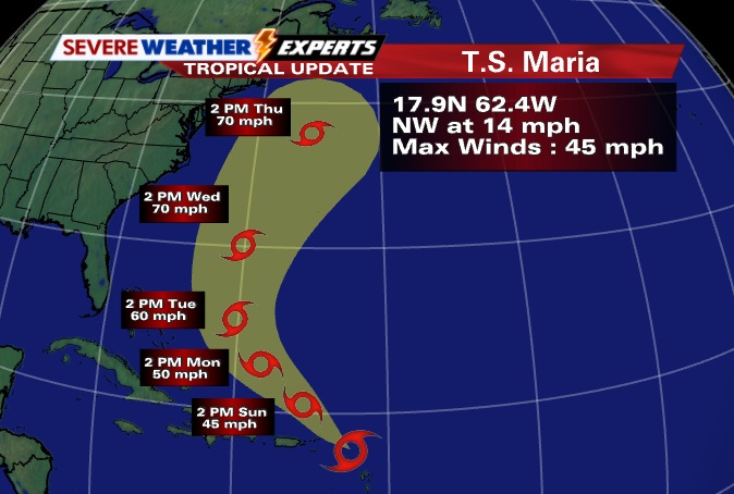
TROPICAL STORM MARIA ADVISORY
5 p.m. update — Center of Maria passing over the northern Leeward Islands, strong winds to remain well north of the islands.
Watches and warnings
There are no coastal watches or warnings in effect.
48-hour outlook
At 5 p.m., the center of Tropical Storm Maria was located near latitude 17.9 north, longitude 62.4 west. Maria is moving toward the northwest near 14 mph. This general motion is expected to continue during the next day or two.
On the forecast track, the center of Maria is expected to move away from the Leeward Islands on Sunday.
Maximum sustained winds are near 45 mph with higher gusts in a few squalls well to the northeast of the center.
Little change in strength is forecast during the next day or two.
Tropical-storm-force winds extend outward up to 200 miles, mainly to the northeast of the center.
Estimated minimum central pressure is 1007 mb or 29.74 inches.
Hazards affecting land
RAINFALL: Maria is expected to produce total rain accumulations of 2 to 4 inches with isolated maximum amounts of 6 inches over the Lesser Antilles, the Virgin Islands and Puerto Rico.
Next advisories
Complete advisory: 11 p.m.
———————————————
TROPICAL STORM NATE ADVISORY
8 p.m. update — Nate moving slowly westward.
Watches and warnings
A Hurricane Warning is in effect for:
Mexico, from Tuxpan to Veracruz
A Hurricane Watch is in effect for:
Mexico, from Tampico to north of Tuxpan
Mexico, from south of Veracruz to Punta El Lagarto
A Tropical Storm Warning is in effect for:
Mexico, from Tampico to north of Tuxpan
Mexico, from south of Veracruz to Punta El Lagarto
48-hour outlook
At 8 p.m., the center of Tropical Storm Nate was located near latitude 20.1 north, longitude 94.7 west. Nate is moving toward the west near 6 mph, and this motion is expected to continue for the next 48 hours.
On the forecast track, the center of Nate will reach the coast of Mexico in the warning area on Sunday.
Maximum sustained winds have increased to near 65 mph with higher gusts. Some strengthening is forecast in the next 24 hours, and Nate is expected to be near hurricane intensity when it makes landfall on Sunday.
Tropical-storm-force winds extend outward up to 105 miles from the center.
The latest minimum central pressure is 999 mb or 29.50 inches.
For the full East Coast surf report go here:
 Become A Sponsor!
If you have a product or service that is a good fit for our surf community, we have opportunities for you to sponsor this blog! Download our media kit now!
